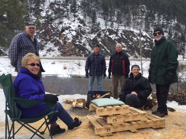
The Winter Picnic – Hike was a success with the help of Tip Anderson. Fourteen people attended in spite of the rainy forecast which never materialized. I spread wood chips around the picnic table while Tip built up a good fire for roasting all our goodies. Everyone enjoyed cooking and visiting, others went fishing, while some went for the hike on the Dewdney Trail. We didn’t bother with snowshoes so broke through the crust in spots but lots of spots were bare. Cathy, Ed and I snowshoed up there a few days before and there is definitely less snow now (or finally!) I presented a brief history on the Dewdney Trail (1860) and pointed out the rock retaining walls visable in spots. Further discussion by Tip and Tom re: its route through Manning via Wells and Grainger. Also explained how PY Point got its name based on a car accident in 1916. Driver, P.Y. Smith, had 4 passengers with him when the car rolled into the river. Thankfully no one was killed. This part of the road was narrow with a very sharp corner that has since been blasted out and widened destroying a popular swimming hole that Darnella recalls from her childhood.
Seven people participated in this snowshoe hike. It was a fine day for a hike with plenty of sunshine and no wind. We left 2 vehicles on the road past the golf course and then drove back to the Princeton Cemetery, “the dead centre of town” (groans). With the help of an old cushion, even those of us who are vertically challenged, managed to cross the barbed wire fence while wearing snowshoes (this may become a winter Olympic Event). We skirted around the old tailings, marvelling at what the mining companies got away with in the past, then got on the old road. The rolling hills are covered with Big Sage (Artemisa tridentata) which gave off a perfume even on a winter day. Following the trail, we saw many tracks of squirrels, coyotes, snowshoe hares, deer, mice, grouse, and even tracks left by a cross country skier. Later in the day, almost at the end of the hike, we saw the parallel marks made by a cougar, eight feet off the ground on a ponderosa pine!
After an hour and a half we reached the lava beds. This area measures 200 metres wide and slopes downwards for half a kilometre. At this time of year the lava beds are covered in snow but some rocks are visible. This area is devoid of all vegetation, whilst the edges are covered in some trees and grasses. The reason for this phenomena is quite unclear. In the distant past Princeton was the site of much volcanic activity, and these lava flows are indicative of this. My question is, “Why isn’t this site covered in glacial deposits like everything else?
Along the way we enjoyed wonderful views, especially looking northward. We stopped for lunch on top of the old Amber Ski Jump and found the tower and bull wheel at the top of the old tow. After lunch we made our way down the steep trail toward the big ponderosa pines above the golf course and down the track of the other tow line. We arrived back at the cars at about 1:00 p.m after our 3 hour hike.
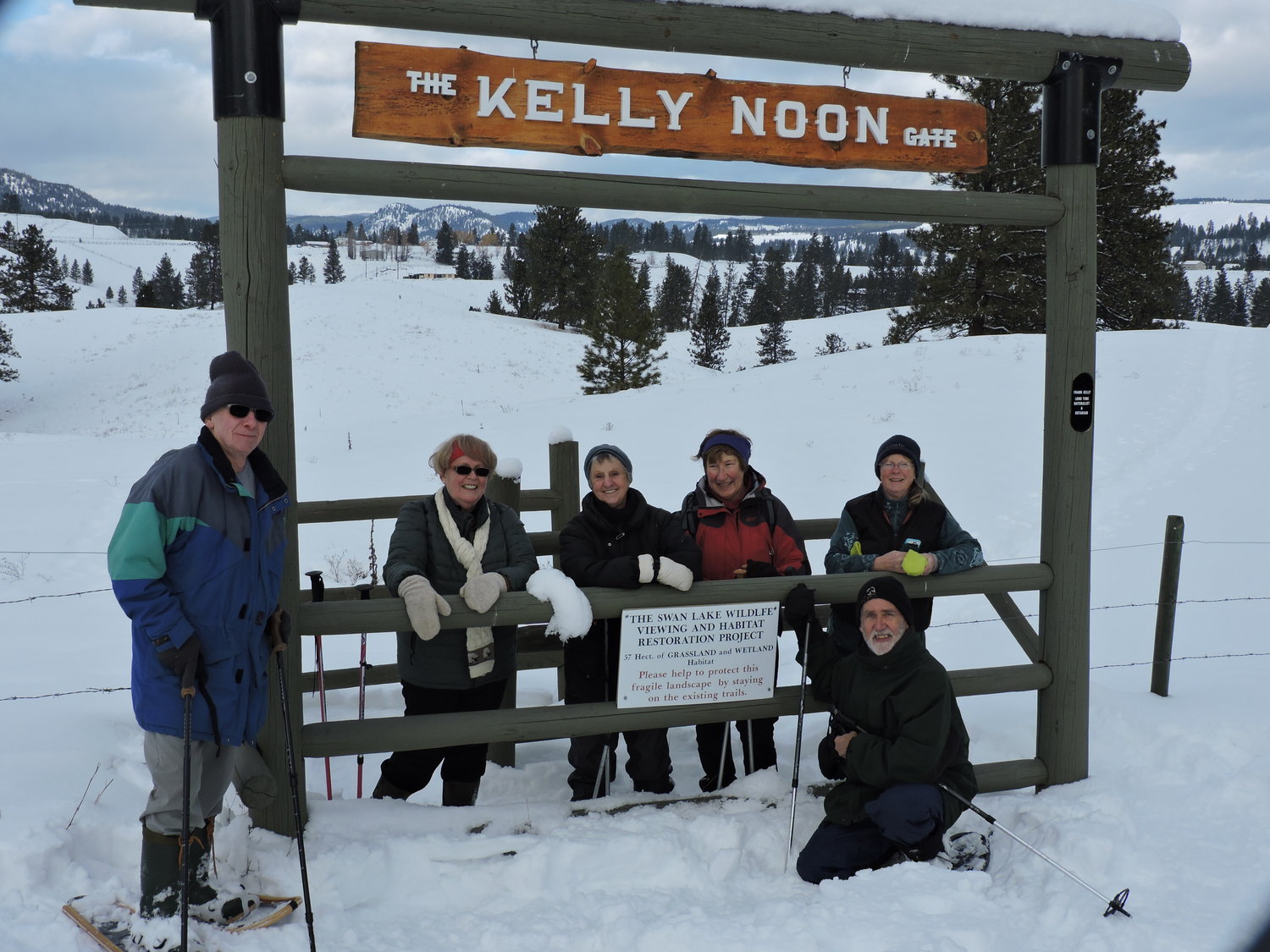
Six members of the Vermilion Forks Field Naturalists and one guest spent about 2 hours snowshoeing the trail at Swan Lake. Part of the trail is new for this winter and it is about 3km in length with a few steeper hills to give you a good workout.
We stopped for a snack break at the picnic table overlooking the lake. The group saw 2 bald eagles, a black-billed magpie and numerous crows and ravens as well as 5 deer and lots of deer tracks. The day was mild after the recent snows with the sun trying to make an appearance.
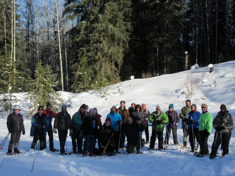
An enthusiastic group of nine naturalists showed up at China Ridge Longhouse on Saturday, Jan. 28th to participate in the snowshoe hike to China Ridge Viewpoint. Following the Parker Owen trail and onto the top of the basalt ridge the group enjoyed views of the Tulameen Valley and the snow covered mountains toward the West. Dropping down to Fence Fun, we crossed the Ridge Trail Cross Country Ski Trail and continued on what is designated as the Parker Bike Trail. Surrounded by remnants of the last giant interior Douglas Fir forest that once covered this area, we then entered a self generated forest as we made their way to the viewpoint. Many tracks of deer, elk, moose, ruffed grouse, snowshoe hare, lynx and the odd cougar track abounded. Reaching the Viewpoint, a view of the Similkameen valley and all points east could be admired. A fire was soon built and a picnic table allowed everyone to have a sit down and enjoy their lunch. Everyone enjoyed themselves and commented how much easier it was than Secret Lake. The actual roundtrip took 3 hours, not 4, and this trail can now be classified as Easy/Moderate. VFFN encourages everyone to come out and enjoy nature in its winter setting.
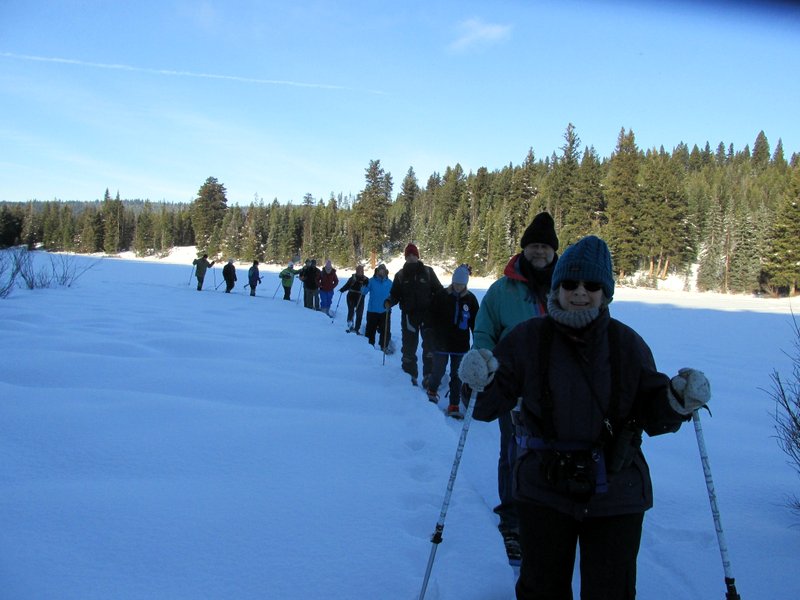
Saturday, January 14th was a little cool at -21 Celcius when 15 members of the Vermillion Forks Field Naturalists ventured to Chain, Secret, Link and Osprey Lakes area. It was their first snowshoe adventure in 2017. Local residents of the area also joined the VFFN to bring the group size to 22. Greg and Terry Tellier from Osprey Lake led the hikers along 8km of trails.
The morning started with a sighting of a juvenile moose at Secret Creek Place just as participants were strapping on their snow shoes. It was a little windy at times but for the most part the skies were bluebird blue and the sun kept the group nice and warm.
Photo by ?
We had some keen birders in the group who identified several species of birds on the four lake trip.
The afternoon ended with a campfire, lunch and last visit to the Budweiser Museum at Tellier’s.
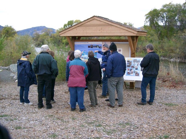
Although the weather was quite cold and a bit foggy, 15 members of VFFN turned out in Oliver to hear local environmentalist Lee McFayden speak about the Okanagan River Restoration Initiative. The talk was given on the banks of the Okanagan River where we observed the spawning salmon as we listened.
The Okanagan River is one of only 3 rivers (the others being, the Wenatchee & the Snake) in the Columbia River system where Sockeye salmon still return to spawn. The run was near extinction by the 1990’s due to flood control programs and 9 hydro electric dams built on the Columbia River. In 1998 Lee McFayden became part of a multi disciplinary group comprised of the Okanagan Nation Alliance, provincial and federal agencies that all came together to form the Okanagan River Restoration Initiative. Their goal was to restore a portion of the Okanagan River in Oliver to its original configuration and thus create spawning beds for the returning Sockeye.
This project is ongoing and has been a greater success then was ever envisioned. The time and effortand just hard work by everyone involved was staggering to hear about. Lee told us that the group initially hoped for the return of about 1,200 Sockeye and have had a return of 50,000!
This is a wonderful project to visit and a very easy walk with a great information kiosk.
The Hope Pass Field Trip took four hours to do at a leisurely pace, (2 hours there; 2 hours back). The level of difficulty was EASY rather than MODERATE. Something to remember for another time. The trail was built in 1861 and sections of the corduroy roads are still visible. These roads, of course, were to facilitate the passage of wagons. Today, the trail wanders through stands of lodgepole pine and spruce.
Stopping occasionally, we examined some of the plants and flowers which were amazing for this time of year. We saw Asters, remains of Lousewort plants which are parasitic on pine and Arrowleaf Groundsell, the remains of Leather-leaf Saxifrage, clumps of Pearly Everlasting, and small Flowered Penstemons. We also found a bewildering number of mushroom species; those recognizable were Lactarius Delicious (edible), Lactarius Rufus (poisonous), Russula Emetica (poisonous), and Hydnum Ibricatum (Hawk Wing) (edible), and others that were unidentifiable. The hike was a pleasant way to spend a lovely, fall day.
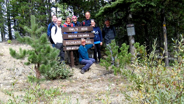
On Saturday 3 September eight VFFN members hiked the Owl’s Head Trail near the old townsite of Blakeburn. Our hike that day was supposed to have taken us to Jim Kelly Peak but the weather in that direction was stormy so we decided to hike closer to home.
The hike took us on what appeared to be a very old trail. There were trees along the way that had been slashed many decades ago and were scarred as a result. Around each of them was a piece of coloured tapes saying, “Culturally modified tree.”
The trail goes up and down through the woods and in a couple of places skirts rocky ridges. We, of course, chose to climb onto the ridges to see the views. We could plainly see the area around Jim Kelly Peak, which was surrounded by clouds and streaks of rain, making us glad we had chosen to change our plans. The trees on the ridges were clinging desperately to the rocks and were gnarled and bent from the wind. In the forest there were many dead trees. Thanks to Kelly Cook and the members of the fire suppression crew, all the deadfall had been cleared off the trail; otherwise the hike would have taken us much longer.
After about an hour of hiking we came upon an old adit (a horizontal tunnel driven into the side of a mountain) with narrow rails sticking out of it. It was obviously an old mine and the rails were for the ore carts. The trail we had walked was presumably the trail to the mine. The adit was on a very precipitous slope and we wondered how in the world the ore was packed out and to where. About half an hour after the adit we came to our destination, a ledge on which there were two collapsing cabins. If this was where the people working the mine lived we wondered where they got their water because the valley with running water was several hundred meters down a cliff below us. The dogged industriousness of these early miners blew us away. Above and to the left of us was a rocky cliff on which was the “owl’s head,” a rock formation that, when the light hits it just right, looks like the head of an owl.
On our way back we stopped again at the adit and Peter Antonick decided to go inside. Because the entrance was partially covered with scree he had to crawl in on his belly. Peter was soon followed by Martin and Alexander whose echoey, muffled voices reached us from way inside the tunnel. About twenty meters inside there was a cavern in which the three of them could stand upright. Peter came out with rock samples containing traces of quartz and what look like gold flake but might have been pyrite.
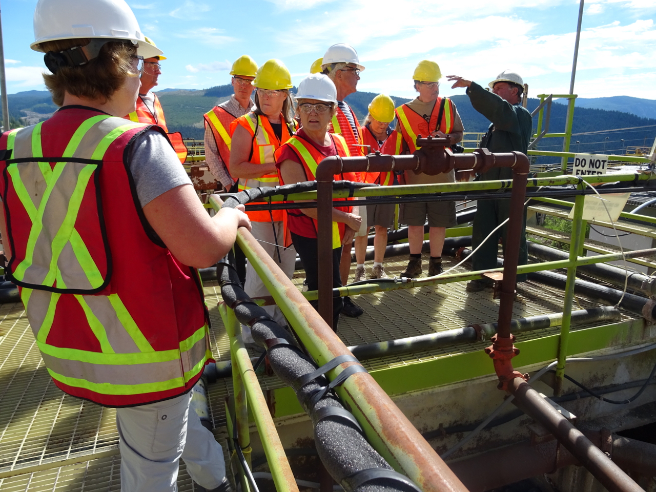
A very steep and winding road with many spectacular views of the Similkameen Valley below brought us to the Nickel Plate Mine Water Treatment Facility.
Barrack Gold Corporation owns the site but never operated it as a mine. It was bought as a bulk purchase of gold properties. The pre-existing Mine Mill Building is used as a treatment centre for contaminated ground water from the previous mine gold extraction process.
Vanessa Bell, Barrick’s senior environmental specialist, indicated that when the Nickel Plate Mine went into production in 1987, many of today’s “best environmental practices for mining” were not in place. The Tailings Storage Facility did not have lined ponds! As a result, the ground water and surrounding soils became contaminated with cyanide and other toxic chemicals used in the gold extraction procedure.
The Water Treatment Facility pumps the water up from the Tailings Site to the Treatment Facility where it is processed using a series of very complicated biological treatments that are actually used in sewage treatment plants. At the last stage the water is analyzed for appropriate chemical levels and purity and then released into Hedley Creek. The amount of the release is proportionate to the levels of water in the creek, less in summer as creek levels are lower. The creek then flows into the Similkameen River. There is also a sludge byproduct with this decontamination process. This sludge could eventually be used by the agricultural sector.
Our guide informed us that the Barrick Gold Corporation is planning some upgrades to the facility. The treatment and remediation plans, however, are open ended and it could take as long as 125 years for the land and ground water to be restored to normal levels. A very sad legacy in our extraction based communities.
Ginty’s Pond, also called Cawston Slough, is a small wetland area in Cawston B.C. It provides a rare opportunity to view a wetland in the process of transitioning into a marshland and eventually becoming dry land.
It was an educational opportunity for the nine members of the VFFN group to tour this area with an exceptional guide. Lee McFayden has lived in the area for almost 50 years. She is one of the original organic farmers in the area and an active environmentalist. She gave us the colourful history of Ginty’s Pond. The ‘Pond’, up until the late 1970’s, was a dynamic community waterway. Residents living along the slough had small boats and docks and skated on it in the winter. This area now has very little open water and is choked with cattails and other invasive plant species. This transition has occurred as a direct result of government road work and the increased withdrawing of water for
irrigation purposes. This has occurred in a relatively short period of time. Lee also pointed out a Cottonwood forest that was almost decimated by a local business using it for animal grazing. Happily it has abundant regrowth.
This wetland is home to more than 70 species of birds and many amphibians. We did see a Lewis Woodpecker, Eastern Kingbirds, a pair of Ospreys and many Mallard Ducks and ducklings. This area is a perfect example of how precious and fragile our wetlands are in the South Okanagan.